FranceJadis logo FranceJadis v1.07

The France of yesteryear, on a map

About 70,000 geolocated old postcards of mainland France, to compare with the places as they stand today.

Start francejadis.fr
Getting the most out of francejadis.fr on iPhone and Android

iPhone · Safari

To display the site without the address bar or tabs — full-screen images then fill the whole screen, in landscape too:

  1. Open francejadis.fr in Safari.
  2. Tap the Share button (square with an upward arrow), in the bar at the bottom or top; if you don't see it, first tap … next to the address.
  3. Tap Add to Home Screen (if needed, More at the bottom of the list).
  4. Leave Open as Web App on, then tap Add.
  5. From then on, launch FranceJadis from this icon rather than from Safari: it opens without Safari's bars, in portrait and landscape.

In Safari itself, the landscape tab bar can be turned off in Settings › Apps › Safari › Landscape Tab Bar.

Android

In the browser, an image already switches to true full screen (no bars) when opened large. To get the whole site without bars:

  • Chrome: menu ⋮ › Add to Home screen (or Install app) › Install.
  • Samsung Internet: menu ☰ › Add page to › Home screen.
  • Firefox: menu ⋮ › Add to Home screen.

Then launch FranceJadis from this icon: it opens full screen, without address bar or status bar. Also turn on auto-rotate to use landscape.

Support this project

The life of this project depends on your support.
Yes, free comes at a cost.

Draft page — text adapted from the app's “About” sheet (to be adjusted). The two screenshots in the “In pictures” section are now the real ones (Combourg).

What is FranceJadis?

FranceJadis grew out of long work on about 70,000 old postcards of mainland France — modest but precious witnesses of France at the beginning of the 20th century.

These pictures tell of villages, streets, trades, landscapes, railway stations, markets, monuments, the figures and gestures of an era that has now vanished. They are only a tiny part of France's heritage, but at their own scale they deserve to be preserved, shared and handed down.

Most of these postcards were digitized around 1990. Over the past few years they have gradually been reread, identified, geolocated as precisely as possible, and for the most part colorized. This colorization should be viewed with caution: it only aims to make the scenes closer, clearer and more alive, without claiming to restore their original colors with certainty.

FranceJadis thus invites you to explore the France of yesteryear and compare it with today's France, thanks to the current views provided by Apple Look Around.

How it works

1

Explore the map

Move around and zoom: when the crosshair turns green, you can search around that point.

2

Discover the postcards

The results appear as thumbnails. Tap one to enlarge it, locate it and look at it closely.

3

Compare with today

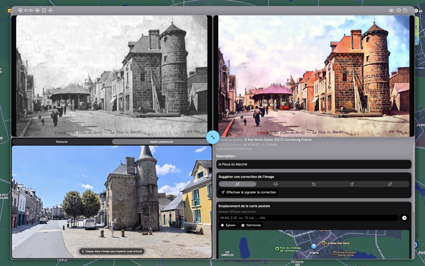
Set the postcard against the place as it stands today, thanks to Apple Look Around.

In pictures
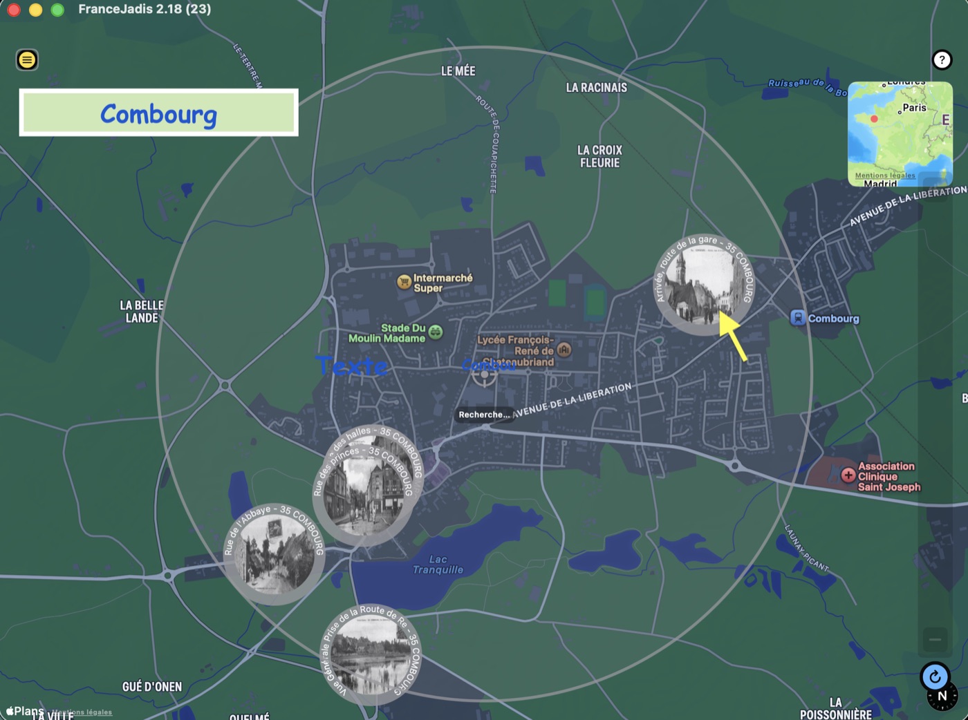
Map of France in FranceJadis, with thumbnails of geolocated old postcards around Combourg
Explore the map: the postcards appear as thumbnails around the point you searched.
An old postcard of the Place du Marché in Combourg compared with the Apple Look Around view of the same place today
Then / now: the same square, compared thanks to Apple Look Around.

A personal adventure

FranceJadis carries on forty years of collecting, digitizing and identifying old postcards — with, in between, a whole life as a commercial website that few visitors know about. The “History of the project” page tells that story; “Origin & rights” answers questions about the legal status of these pictures.